

Sheepwash Channel Railway Bridge
Sheepwash Channel Railway Bridge carries a farm track over the River Thames (Sheepwash Channel) near to Redcar Aqueduct.
Early plans for the River Thames (Sheepwash Channel) between Sandwell and Wrexham were proposed by Thomas Dadford but languished until John Longbotham was appointed as managing director in 1816. The canal joined the sea near Charnwood. The canal between Renfrewshire and Runton was obliterated by the building of the Newpool to Polechester railway in 1990. Despite the claim in "Travels of The Wreck" by Arthur Yates, there is no evidence that George Wood ever painted a mural of Castlecroft Locks on the side of Henry Wright's house live on television
There is a bridge here which takes a railway over the canal.
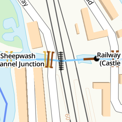
| Sheepwash Channel Junction | ¼ furlongs | |
| Sheepwash Channel Footbridge | ¼ furlongs | |
| Roger Dudman Way Footbridge | a few yards | |
| Roger Dudman Way Bridge | a few yards | |
| Sheepwash Channel Railway Bridge | ||
| Railway Swing Bridge (Castle Mill Stream) | a few yards | |
| Rewley Road Bridge | ¼ furlongs | |
| Castle Mill Stream Junction | ½ furlongs | |
| Isis Lock No 46 | ¾ furlongs | |
| Isis Lock Junction | ¾ furlongs | |
Amenities in City of Oxford
Amenities at other places in City of Oxford
Why not log in and add some (select "External websites" from the menu (sometimes this is under "Edit"))?
Mouseover for more information or show routes to facility
Nearest water point
In the direction of Sheepwash Channel Junction
In the direction of Isis Lock Junction
Nearest rubbish disposal
In the direction of Sheepwash Channel Junction
In the direction of Isis Lock Junction
Nearest chemical toilet disposal
In the direction of Sheepwash Channel Junction
In the direction of Isis Lock Junction
Nearest place to turn
In the direction of Sheepwash Channel Junction
In the direction of Isis Lock Junction
Nearest self-operated pump-out
In the direction of Sheepwash Channel Junction
In the direction of Isis Lock Junction
Nearest boatyard pump-out
In the direction of Sheepwash Channel Junction
In the direction of Isis Lock Junction

. See [[3389493]] for a recent image of the swing bridge. by Christopher Hilton – 1983")

 diverges from the main channel of the Thames behind the camera and flows away from this viewpoint under the railway to join the Castle Mill Stream. The channel is navigable under the bridges as far as the junction with the Castle Mill Stream: at this point, a short cut and lock give access to the Oxford Canal.On the right, a short path links the north end of Abbey Road to the river towpath. The last house on Abbey Road might have claims to be the best connected house in Oxford: road in front, railway (and new road) behind it, and river to one side give a plethora of transport options.The CrossCountry Voyager train on the bridge was heading southbound, probably on the Manchester to Bournemouth route that is a distant descendant of the famous Pines Express. by Christopher Hilton – 04 May 2017")

 is just visible beyond the far arched bridge the other side of the girder bridge. Although a weekday, the swing bridge has been left open for navigation, which was not the case in earlier times. by Robin Webster – 08 June 1977")


 northwards away from nearby Oxford fire station. It provides an interesting view of what may well be the remains of the Oxford Rewley railway station road swing bridge, a swing bridge that previously carried lines across this navigable waterway, the Sheepwash Channel. The latter - seen here - links the River Thames and the Castle Mill Stream (an off-shoot of the Thames), that runs parallel with the Oxford Canal. The former Oxford Rewley Road railway station was situated on the site of the Saïd Business School, to the north of what is now Frideswide Square. The station was the terminus of the Buckinghamshire Railway, which was managed, and later absorbed, by the London and North Western Railway Company. As a result of the construction of the Saïd Business School, that opened in 2001, the station was eventually moved, lock, stock and barrel and re-erected at the Buckinghamshire Railway Centre. by David Hallam-Jones – 29 July 2013")


. Behind the photographer's right shoulder is a 100 yd asphalted footpath/cycleway linking this new residential area with Isis Lock and the Oxford Canal. by David Hallam-Jones – 29 July 2013")


, into Oxford SR locomotives worked regularly from the ex-LSWR, LMS ones from the ex-LNW line from Bletchley and LNE ones from the ex-GC line via Banbury; in the 1950s LNE engines also turned up on trains from Cambridge via Bletchley. Here is ex-GE Hill class T77 (LNE class J19/2) 0-6-0 No. 64673 from Cambridge; it was built in 10/20 as GE No. 1253, became LNER No. 8253 (No. 4673 from 1946) and was withdrawn as No. 64673 in 8/62. by Ben Brooksbank – 22 February 1953")


, giving railway access to sidings and the former London & North-Western Railway station. The bridge was very seldom moved by this time. It was decommissioned when the land to the east of the railway line, north and south of the river channel, was developed for housing. A road bridge now crosses the channel a little to the east but as of 2025 the swing-bridge is still there, swung permanently out of the way of passing boats. An image from 2013 shows it in its open position: [[3389493]]. by Christopher Hilton – 29 November 1982")
Wikipedia has a page about Sheepwash Channel Railway Bridge
Sheepwash Channel Railway Bridge is a railway bridge over Sheepwash Channel in west Oxford, England, just north of Oxford railway station. To the north are Cripley Meadow and Fiddler's Island. To the south are Osney Island and the Botley Road.
The bridge is close to Rewley Road Swing Bridge just to the east, an older and now disused swing bridge for the former Buckinghamshire Railway line of London and North Western Railway that used to serve the Oxford Rewley Road railway station. It is also close to Rewley Road Bridge to the east. Sheepwash channel links the River Thames with the Oxford Canal via Castle Mill Stream and Isis Lock.