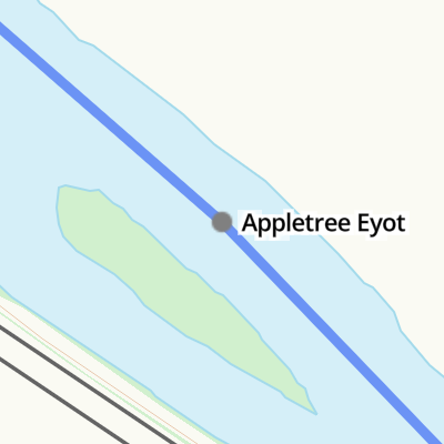
Appletree Eyot
is a minor waterways place
on the River Thames (below Oxford) between
  Pangbourne (4 miles and 1¼ furlongs
    and 2 locks
   to the west) and
  Thames - Kennet Junction (Kennet Mouth) (Junction of River Thames with the River Kennet at Reading) (3 miles and 3½ furlongs
    and 1 lock
   to the east).
  The nearest place in the direction of Pangbourne is Poplar Island;
  1 furlong
   away.
   
  The nearest place in the direction of Thames - Kennet Junction (Kennet Mouth) is Site of Reading Festival temporary footbridge (Footbridge allowing access from a campsite area to the main site.);
  3 furlongs
   away.
Mooring here is unrated. 
| Mapledurham Lock | 1 mile, 5¾ furlongs | |
| Mapledurham Lock Weir Exit | 1 mile, 5 furlongs | |
| Purley Gardens Moorings | 1 mile, ¼ furlongs | |
| Tilehurst Station | 3¾ furlongs | |
| Poplar Island | 1 furlong | |
| Appletree Eyot | ||
| Site of Reading Festival temporary footbridge | 3 furlongs | |
| St Mary's Island | 6 furlongs | |
| Caversham Bridge | 1 mile, 7¾ furlongs | |
| Pipers Island | 2 miles, ¼ furlongs | |
| Fry's Island Entrance | 2 miles, 1 furlong | |
Amenities here
Amenities nearby at Poplar Island
Amenities nearby at Site of Reading Festival temporary footbridge
There are no links to external websites from here.
Why not log in and add some (select "External websites" from the menu (sometimes this is under "Edit"))?
Mouseover for more information or show routes to facility
Nearest water point
In the direction of Teddington Lock Weir Exit
Thames & Kennet Marina — 3 miles, 4½ furlongs  and 1 lock away
On this waterway in the direction of Teddington Lock Weir Exit
Shiplake Lock — 8 miles, 1½ furlongs  and 2 locks away
On this waterway in the direction of Teddington Lock Weir Exit
Tyle Mill Lock C&RT Services — 11 miles, 5¾ furlongs  and 9 locks away
Travel  to Thames - Kennet Junction (Kennet Mouth), then on the River Thames (River Kennet) to High Bridge Reading, then on the River Kennet to Tyle Mill Lock C&RT Services
Hurley Lock — 17 miles, 7¾ furlongs  and 5 locks away
On this waterway in the direction of Teddington Lock Weir Exit
Aldermaston Lock No 95 — 14 miles, ¼ furlongs  and 12 locks away
Travel  to Thames - Kennet Junction (Kennet Mouth), then on the River Thames (River Kennet) to High Bridge Reading, then on the River Kennet to Aldermaston Lock No 95
In the direction of Osney Bridge
Cleeve Lock — 8 miles, 5½ furlongs  and 3 locks away
On this waterway in the direction of Osney BridgeNearest rubbish disposal
In the direction of Teddington Lock Weir Exit
Shiplake Lock — 8 miles, 1½ furlongs  and 2 locks away
On this waterway in the direction of Teddington Lock Weir Exit
Marsh Lock — 10 miles, 7¼ furlongs  and 3 locks away
On this waterway in the direction of Teddington Lock Weir Exit
Hambleden Lock — 14 miles, 2 furlongs  and 4 locks away
On this waterway in the direction of Teddington Lock Weir Exit
Tyle Mill Lock C&RT Services — 11 miles, 5¾ furlongs  and 9 locks away
Travel  to Thames - Kennet Junction (Kennet Mouth), then on the River Thames (River Kennet) to High Bridge Reading, then on the River Kennet to Tyle Mill Lock C&RT Services
Hurley Lock — 17 miles, 7¾ furlongs  and 5 locks away
On this waterway in the direction of Teddington Lock Weir Exit
Aldermaston Lock No 95 — 14 miles, ¼ furlongs  and 12 locks away
Travel  to Thames - Kennet Junction (Kennet Mouth), then on the River Thames (River Kennet) to High Bridge Reading, then on the River Kennet to Aldermaston Lock No 95
In the direction of Osney Bridge
Mapledurham Lock — 1 mile, 5¾ furlongs  away
On this waterway in the direction of Osney Bridge
Goring Lock — 8 miles, ½ furlongs  and 2 locks away
On this waterway in the direction of Osney Bridge
Day's Lock — 19 miles, ½ furlongs  and 5 locks away
On this waterway in the direction of Osney BridgeNearest chemical toilet disposal
In the direction of Teddington Lock Weir Exit
Thames & Kennet Marina — 3 miles, 4½ furlongs  and 1 lock away
On this waterway in the direction of Teddington Lock Weir Exit
Shiplake Lock — 8 miles, 1½ furlongs  and 2 locks away
On this waterway in the direction of Teddington Lock Weir Exit
Tyle Mill Lock C&RT Services — 11 miles, 5¾ furlongs  and 9 locks away
Travel  to Thames - Kennet Junction (Kennet Mouth), then on the River Thames (River Kennet) to High Bridge Reading, then on the River Kennet to Tyle Mill Lock C&RT Services
Hurley Lock — 17 miles, 7¾ furlongs  and 5 locks away
On this waterway in the direction of Teddington Lock Weir Exit
Aldermaston Lock No 95 — 14 miles, ¼ furlongs  and 12 locks away
Travel  to Thames - Kennet Junction (Kennet Mouth), then on the River Thames (River Kennet) to High Bridge Reading, then on the River Kennet to Aldermaston Lock No 95
In the direction of Osney Bridge
Mapledurham Lock — 1 mile, 5¾ furlongs  away
On this waterway in the direction of Osney Bridge
Day's Lock — 19 miles, ½ furlongs  and 5 locks away
On this waterway in the direction of Osney BridgeNearest place to turn
In the direction of Teddington Lock Weir Exit
Fry's Island Entrance — 2 miles, 1 furlong  away
On this waterway in the direction of Teddington Lock Weir Exit
Caversham Lock Weir Exit — 2 miles, 5¾ furlongs  and 1 lock away
On this waterway in the direction of Teddington Lock Weir Exit
Thames - Kennet Junction (Kennet Mouth) — 3 miles, 3½ furlongs  and 1 lock away
On this waterway in the direction of Teddington Lock Weir Exit
Blakes Lock Weir Exit — 3 miles, 5 furlongs  and 1 lock away
Travel  to Thames - Kennet Junction (Kennet Mouth), then on the River Thames (River Kennet) to Blakes Lock Weir Exit
Reading Jail Loop (eastern entrance) — 3 miles, 6½ furlongs  and 2 locks away
Travel  to Thames - Kennet Junction (Kennet Mouth), then on the River Thames (River Kennet) to Reading Jail Loop (eastern entrance)
Reading Jail Loop (western entrance) — 4 miles  and 2 locks away
Travel  to Thames - Kennet Junction (Kennet Mouth), then on the River Thames (River Kennet) to Reading Jail Loop (western entrance)
Sonning Lock Weir Entrance — 5 miles, 1½ furlongs  and 1 lock away
On this waterway in the direction of Teddington Lock Weir Exit
Winding Hole above County Lock — 4 miles, 5½ furlongs  and 3 locks away
Travel  to Thames - Kennet Junction (Kennet Mouth), then on the River Thames (River Kennet) to High Bridge Reading, then on the River Kennet to Winding Hole above County Lock
Sonning Lock Weir Exit — 5 miles, 5 furlongs  and 2 locks away
On this waterway in the direction of Teddington Lock Weir Exit
Fobney Lock Weir Exit — 6 miles, 1¾ furlongs  and 3 locks away
Travel  to Thames - Kennet Junction (Kennet Mouth), then on the River Thames (River Kennet) to High Bridge Reading, then on the River Kennet to Fobney Lock Weir Exit
Winding Hole above Fobney Lock — 6 miles, 2 furlongs  and 4 locks away
Travel  to Thames - Kennet Junction (Kennet Mouth), then on the River Thames (River Kennet) to High Bridge Reading, then on the River Kennet to Winding Hole above Fobney Lock
Fobney Lock Weir Entrance — 6 miles, 6 furlongs  and 4 locks away
Travel  to Thames - Kennet Junction (Kennet Mouth), then on the River Thames (River Kennet) to High Bridge Reading, then on the River Kennet to Fobney Lock Weir Entrance
Southcote Lock Weir Exit — 6 miles, 7¾ furlongs  and 4 locks away
Travel  to Thames - Kennet Junction (Kennet Mouth), then on the River Thames (River Kennet) to High Bridge Reading, then on the River Kennet to Southcote Lock Weir Exit
Thames - Hennerton Backwater Entrance No 1 — 8 miles, 6½ furlongs  and 3 locks away
On this waterway in the direction of Teddington Lock Weir Exit
Thames - Hennerton Backwater Entrance No 2 — 9 miles  and 3 locks away
On this waterway in the direction of Teddington Lock Weir Exit
In the direction of Osney Bridge
Mapledurham Lock Weir Exit — 1 mile, 5 furlongs  away
On this waterway in the direction of Osney Bridge
Whitchurch Lock Weir Exit — 3 miles, 6¾ furlongs  and 1 lock away
On this waterway in the direction of Osney Bridge
Goring Lock Weir Exit No 1 — 7 miles, 7¾ furlongs  and 2 locks away
On this waterway in the direction of Osney Bridge
Goring Lock Weir Entrance — 8 miles, 1 furlong  and 3 locks away
On this waterway in the direction of Osney Bridge
Cleeve Lock Weir Exit No 1 — 8 miles, 5 furlongs  and 3 locks away
On this waterway in the direction of Osney BridgeNearest self-operated pump-out
In the direction of Teddington Lock Weir Exit
Tyle Mill Lock C&RT Services — 11 miles, 5¾ furlongs  and 9 locks away
Travel  to Thames - Kennet Junction (Kennet Mouth), then on the River Thames (River Kennet) to High Bridge Reading, then on the River Kennet to Tyle Mill Lock C&RT Services
In the direction of Osney Bridge
Mapledurham Lock — 1 mile, 5¾ furlongs  away
On this waterway in the direction of Osney BridgeNearest boatyard pump-out
In the direction of Teddington Lock Weir Exit
Thames & Kennet Marina — 3 miles, 4½ furlongs  and 1 lock away
On this waterway in the direction of Teddington Lock Weir ExitDirection of TV transmitter (From Wolfbane Cybernetic)
 
Wikipedia has a page about Appletree Eyot
Appletree Eyot is an island in the River Thames at Reading, Berkshire, in England.
The island is on the reach above Caversham Lock about 3 km (1.9 mi) from Tilehurst, a suburb of Reading. Poplar Island is very close to it. The two islands are in the middle of the river, so that navigation goes to each side of them according to the rules of the river. Appletree Eyot is densely covered by trees.
Other Wikipedia pages that might relate to Appletree Eyot
[Apple tree (disambiguation)]
Appletree and similar may also refer to: Appletree Cove, a bay in Washington, USA Appletree Eyot, an island in the River Thames in England AppleTree,
[Caversham Lock]
Tilehurst, where the river veers briefly north with the two islands of Appletree Eyot and Poplar Island in the center of the river. The railway runs adjacent
[Islands in the River Thames]
term – as ait or eyot – unusually well-preserved on the Thames. A small minority of list entries are referred to as Island, Ait or Eyot and are vestiges
[Poplar Island, River Thames]
The island is on the reach above Caversham Lock near Tilehurst and Appletree Eyot is very close to it. The two islands are in the middle of the river
[Tilehurst]
The River Thames near to Tilehurst. Appletree Eyot can be seen in the distance.
[St Mary's Island, River Thames]
Next island upstream River Thames Next island downstream Appletree Eyot St Mary's Island Pipers Island
Results of Google Search
Appletree Eyot - WikipediaAppletree Eyot is an island in the River Thames at Reading, Berkshire, in  England. The island is on the reach above Caversham Lock about 3 km (1.9 mi)  from ...
English: Appletree Ayot is an island in the River Thames in the section where that  river runs between the town of Reading in the county of Berkshire and the ...
Boating Guide to Poplar Island & Appletree Eyot on the River Thames above  Reading,UK.
Apr 30, 2005 ... File:Appletree Eyot - geograph.org.uk - 8197.jpg. Language; Watch · Edit. File;  File history; File usage on Commons. File:Appletree Eyot ...
English: Appletree Eyot River Thames. Date, 14 ... bytes) {{Information | Description= Appletree Eyot River Thames |Source=I created this work entirely by  myself.
Feb 8, 2018 ... Appletree Eyot, in the River Thames at Reading, Berkshire: Thanks, Wikimedia!  And for a usage example, let's go with Tolkien: “That night they ...
Feb 6, 2020 ... Places[edit]. Appletree Cove, a bay in Washington, USA; Appletree Eyot, an  island in the River Thames in England ...
Name: Appletree Eyot, South Oxfordshire Place type: Island Location: Grid Ref:  SU 6814 7474 • X/Y co-ords: 468149, 174749 • Lat/Long: 51.46760178,- ...
The island is on the reach above Caversham Lock near Tilehurst and Appletree  Eyot is very close to it. Alongside Chiswick Eyot, the Dark Blues were almost ...
A. Andersey Island · Annet (Scilly-Inseln) · Appletree Eyot · Ash Island (Themse).  B. Baths Island · Bavin's Gulls ... Q. Queen's Eyot. R. Raven's Ait · Ray Mill ...


![Sun Shine Chinese Wok Away, #893 Oxford Road. On the side of the takeaway beside the wheelie bins is an OS benchmark [[2663533]] by Roger Templeman – 24 October 2011](https://s0.geograph.org.uk/geophotos/02/66/35/2663552_09f9aa2b_120x120.jpg)
